Civil & Environmental Engineering
Non Intrusive Geophysical Ground Investigation
This research area focuses on the development and implementation of non-invasive monitoring methods which enable an enhanced understanding of the subsurface. Some of the techniques currently being investigated are described below.
Geophysical assessment & geotechnical monitoring of flood defence embankments


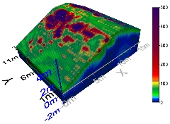
Images showing 3D Electrical Resistivity Tomography (Desicated zones at thorngumbald embankment near Hull, UK)
3D Electrical Resistivity Tomography can be used for many different issues, such as:
- Applied to sea level change and extreme events
- Desication fissuring, piping, erosion which is a major risk for population and habitations
Contaminant transport in soil detection using miniature resistivity
Soil Scaled models

Diesel transport monitoring in soil laboratory model under flow conditions
The principal aim of this study was to assess the scope of monitoring diesel plume migration in a scaled aquifer model with a miniaturised electrical resistivity array. Inverted time-lapse electrical resistivity tomography (ERT) data reflect downward and lateral spreading of the diesel plume away from the injection point in the unsaturated zone. Diesel was also imaged to spread upwards and laterally away from the injection point in the saturated zone, as controlled by capillary rise.
In both cases later-time ERT images reflected preferential pooling of diesel on the water table, as well as vertical smearing of pooled diesel in response to simulated water-table fluctuations.
Geophysical applications
Non-intrusive Geophysical investigation of wind turbine sites on utility landholdings
One important aspect of the supply chain for wind energy and wind farms is to assess the soil conditions of onshore and offshore wind turbines during their all life cycle from (field investigation before installation, settlement and wind loading influence during operation and dismantlement)
Geophysical seabed testing
To mitigate the risk of unforeseen ground conditions, ground disturbance, scouring of under water foundations
Projects
Flood embankments
- ICE/Scottish Government (2008-2010)
- AXA research fund (Jan 2010-June2011)
- FP7-IOF RISMAC (July 20011-July 2013)
- DTG scholarship (EPSRC) (Jan 2009-Jan2012)
- KTA emerging fund Strathclyde (Oct 2011-Oct 2012)
- DTG Scholarship (EPSRC) (2009-2013) “New Eco-tracers for monitoring the fissuring of flood defence embankments”
- DTG Scholarship (2013-2016) “Non-intrusive geophysical investigation of energy infrastructure from climate change with a particular focussing on major river and coastal flood defences”.
Wind turbines
- Encompass with EML group
- Scholarship (2013-2016)“Non-intrusive Geophysical investigation of offshore and onshore wind turbine sites on utility landholdings”
Seabed testing
- Application for Interface Scheme with Storas Uibhist