Images of climate innovation
Measuring biomass with satellite data
This illustration shows scientists measuring all the trees in several small sample plots of forests. They compare their measurements with satellite radar data and LiDAR (laser) data of the same area. This allows them to refine their satellite data analysis in order to use it on vast areas of woodland so that they can measure how many tons of carbon are stored in a forest and precisely monitor changes in tree coverage.
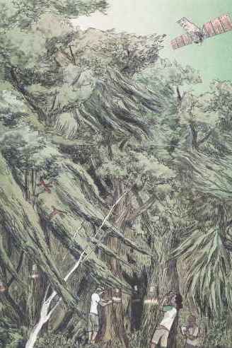
To measure biomass, scientists measure the trees in several small sample plots of forest (normally every tree over 10cm dbh, diameter at breast height). They choose plots that are representative of the broader area. There, they measure and mark each tree (diameter and height) and identify the species of each tree in order to have information on the density of the wood. This process will give them a very good estimate of the biomass: the weight of all the tree material in the perimeter. They then compare and calibrate their measurements with optical, radar (microwaves) and LiDAR (laser) satellite data of the same areas.
This comparison allows them to refine their satellite data analysis in order to use it on vast areas of woodland and on areas that may not be accessible. Thus they can measure how many tons of carbon are stored in a forest and precisely monitor changes in tree coverage. They will be able to see, for example, where trees are growing, if areas are being cut down or planted, and minor changes in tree coverage (called forest degradation).
This image and the accompanying graphic novella 'The Return' are the work of illustrator and writer Cecile Simonis. The project has been shortlisted for the World Illustration Awards. This work has been commissioned as part of the Space and Satellites Artist Residency programme for Inspace at Design Informatics, funded by Data-Driven Innovation and supported by Edinburgh Futures Institutes. Inspace is part of the Institute of Design Informatics; commissioning and producing creative activity that unlocks digital technology and explores its role in society. Their public programme connects data, research and creative talent. During the residency, illustrator, Cecile Simonis, exchanged with scientists working in the field of biomass measuring and forest monitoring using satellite data. She created a work of fiction based on their field of research.
Entrant: Cecile Simonis , University of Edinburgh
Copyright: Cecile Simonis
Funding: Data-Driven Innovation (DDI) programme
Collaborators: Prof Murray Collins, Dr Iain McNicol, Dr Keiko Nomura and Prof Ed Mitchard (University of Edinburgh).